
Drones in Wildlife & Ecology
Collaborators in Wildlife & Ecology


Tailored drone solutions and advanced data analytics for biodiversity and wildlife projects
At Ripper Corp, we specialise in providing customised drone solutions that are tailored to meet the specific needs of each conservation and wildlife project.
Our expertise in drone technology allows us to adapt and design systems that optimise operations, whether it’s for tracking wildlife movements, monitoring habitat changes, or collecting data for conservation projects. We work closely with our clients to understand their unique challenges and objectives, ensuring our drone solutions deliver the most effective results.
In addition to our tailored drone services, Ripper Corp harnesses the power of advanced data analytics and artificial intelligence to deepen our understanding of wildlife patterns and environmental changes.
Our systems process the vast amounts of data collected by our drones, transforming them into actionable insights. This enables more informed decision-making and strategic planning in conservation efforts and wildlife management, enhancing efficiency and effectiveness in field operations.
Drone technology has transformed a number of sectors in Australia and across the globe. Wildlife and ecology is no exception, and drones are enabling great outcomes in this space.
Drones are not only being used to improve our understanding of biodiversity, but changing the way we approach conservation practices.

The benefits of drones for wildlife tracking
and monitoring vs traditional methods
Wildlife drones are used in many ways, whether they’re drones for wildlife surveys, drones for tracking wildlife, drones for research and observation, or drones for conservation efforts. Here’s how drones in wildlife projects stack up against more traditional methods.
Thermal imaging and night surveys
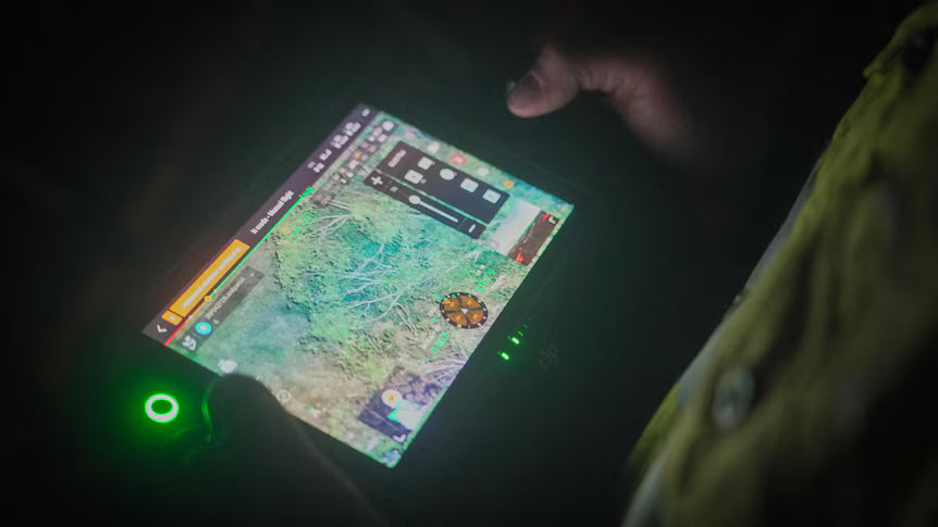
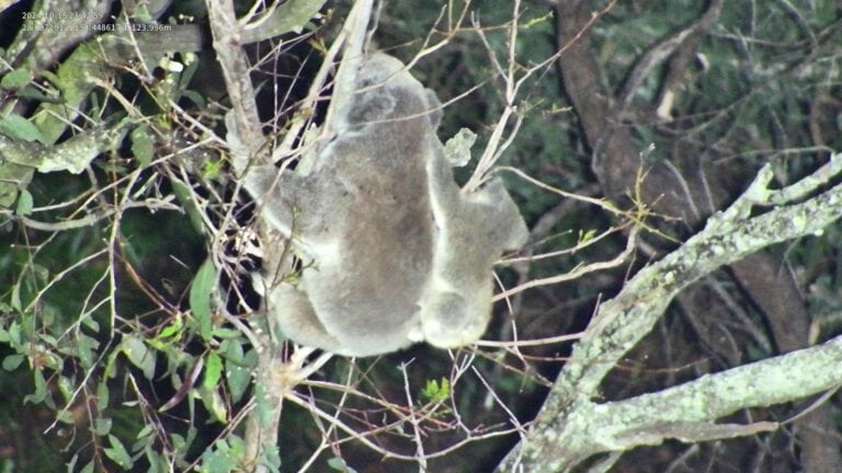
Since they can be equipped with thermal imaging cameras, drones are capable of conducting detailed surveys at night. This technology unveils the nocturnal activities of wildlife, providing insights that are vital for comprehensive ecological studies and enhancing our understanding of animal behaviours in their natural habitat.
GPS and advanced sensors
Drones equipped with GPS and advanced sensors excel in tracking and monitoring wildlife. They collect data on animal movement patterns and health from a safe distance, enabling researchers to study migratory and endangered species with direct interference, reducing stress on wild animal populations.
Efficiency and reach
One of the most significant advantages of using drones in wildlife research is their efficiency.
Drones can cover large areas in a fraction of the time it would take using ground-based methods. This not only saves time but also reduces the costs associated with extensive field surveys.
Minimising disturbance
Traditional wildlife research methods often require close proximity to animals, which can cause stress and behavioural changes in wildlife.
Drones wildlife can't detect easily, on the other hand, allow for data collection from a safe distance, minimising disturbance to animals and their habitats.
Enhanced data quality
Drones provide high-quality, and even real-time data that is often more accurate and detailed than what can be gathered through traditional methods.
This can include 3D mapping, thermal imaging, and high-resolution photography and videography.
Accessibility and safety
Drones can access remote, rugged, or otherwise inaccessible areas with ease, allowing researchers to study wildlife in previously unreachable habitats. Additionally, drones enhance safety by reducing the need for researchers to enter potentially hazardous environments.

Ripper Corp is leading the way forward with drones for wildlife spotting, surveys and conservation efforts
For wildlife survey and research teams, the integration of drone technology represents a significant leap forward in data collection and analysis. Drones not only offer a more efficient, less invasive, and safer means of studying wildlife but also open new possibilities for conservation efforts.
As this technology continues to evolve and its role in wildlife research is set to become even more pivotal, Ripper Corp is committed to remaining at the forefront of developments and play a crucial role in the future of Australia’s biodiversity and habitat conservation.
Drones for wildlife surveys
In Australia, drones are increasingly being used for wildlife surveys, offering a less intrusive and more comprehensive method of data collection compared to traditional ground-based surveys. Wildlife drones equipped with high-resolution cameras and other sensory equipment can cover vast areas quickly, providing detailed images and data that help in monitoring large terrains, and local animal populations and their habitats. By using drones equipped with GPS and other tracking technologies, researchers can gather real-time data on the movement and health of animals, mapping the wildlife and their movements. Drones have revolutionised the way wildlife surveys are conducted, by providing researchers with high-resolution imagery and video data, and the ability to get the bigger picture, quickly.
Drones and wildlife mapping
The use of drones for tracking wildlife has opened new possibilities in the study of animal behaviour and migration patterns.
In wildlife mapping, drones offer a bird’s-eye view, allowing for the creation of detailed habitat maps. These maps are crucial for understanding spatial distribution, habitat usage, and environmental factors affecting wildlife. Drones generate high-resolution maps and this data is vital for identifying critical habitats, migration corridors, and potential threats to wildlife. Using drones for mapping wildlife is particularly useful in studying species that are elusive or endangered, as it minimises human interference while providing accurate and timely information on the populations and locations of wildlife.

Why choose Ripper Corp
Ripper Corp is a leading drone and technology company that specialises in advanced flight operations, top-quality training, and innovative technology. Ripper Corp’s fleet of drones is equipped with all of the technical elements that you need for your wildlife efforts. Our drones feature state-of-the-art technology, including high-resolution cameras, thermal imaging, and GPS tracking systems of the highest quality.
Featured News
Eyes in the Sky for Logan’s Wildlife!
We’ve just completed a Thermal Wildlife Survey in Logan, working in partnership with the City Council to locate endangered Koalas and Greater Gliders as part of the Council's conservation and land management plan.

University of Queensland Community Grant
There is an official survey being conducted under a Queensland Government community grant by the University of Queensland and Ripper Corporation Drones. It aims to improve methods to assess koala populations using thermal imaging…
Ripper Drones survey with University of Queensland
Dr. Diana Fisher, from the University of Queensland and Ripper Corporation, is conducting a study to help count the Burleigh Koalas and observe how they move across the Burleigh Headlands, Ridge Park, and Tallebudgera Conservation Park reserve. Th...